TomTom launches Orbis Lane Model Maps for fresh, lane-level precision at scale
AMSTERDAM, Jan. 02, 2026 (GLOBE NEWSWIRE) -- TomTom (TOM2), the mapping and location technology specialist, today showcased its TomTom Orbis Lane Model Maps, demonstrating the automation and scalability of the Orbis AI map data factory, proving its readiness to serve as a single, high-fidelity source for both automated driving (AD) and navigation systems.
Orbis Lane Model Maps delivers lane-level intelligence, such as lane geometry, connectivity, and markings, at true urban scale. By leveraging an AI-powered map-factory approach, TomTom can produce lane-accurate maps with exceptional efficiency for all roads throughout a wide territory or region. As a result, TomTom Orbis Lane Model Maps can already be available with lane-level geometry across Germany. TomTom is rapidly scaling to many countries to cover the demands of our customers, ensuring they have access to the same level of lane-level detail across the whole regions where they have their operations.
This combination of breadth and freshness is essential for advanced driver-assistance systems (ADAS) and automated driving, enabling vehicles to make safer, more precise decisions on the road. Unlike traditional HD maps, which can be expensive to expand city-wide and slow to refresh, Orbis Lane Model Maps has the same HD richness while being engineered to scale across the whole road network, including the urban road network at a fraction of the cost while remaining continuously up to date as road conditions change.
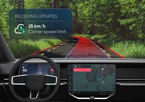
Car manufacturers’ AD stacks can utilize Orbis Maps content to optimize real-time scene understanding in complex environments and to provide context about what lies ahead, including road layout, speed adjustments, thus working in conjunction with the sensors every step of the way.
“Delivering a safe and exceptional experience for next-generation automated driving requires cost-efficient maps with more features, higher accuracy, and fresh updates across all road types, including urban environments,” said Michael Harrell, SVP for Product Engineering, TomTom. “Our innovative solutions are accelerating the scalability of automated driving in complex urban environments.”
About TomTom:
Billions of data points. Millions of sources. Hundreds of communities.
We are the mapmaker bringing it all together to build the world’s smartest map. We provide location data and technology to drivers, carmakers, businesses, and developers. Our application-ready maps, routing, real-time traffic, APIs, and SDKs enable the dreamers and doers to shape the future of mobility.
For further information:
Media Relations
Investor Relations
A photo accompanying this announcement is available at https://www.globenewswire.com/NewsRoom/AttachmentNg/914851d0-268d-4d9a-aac7-e6d8f329998b

![]()
TomTom launches Orbis Lane Model Maps for fresh, lane-level precision at scale
TomTom launches Orbis Lane Model Maps for fresh, lane-level precision at scale
Legal Disclaimer:
EIN Presswire provides this news content "as is" without warranty of any kind. We do not accept any responsibility or liability for the accuracy, content, images, videos, licenses, completeness, legality, or reliability of the information contained in this article. If you have any complaints or copyright issues related to this article, kindly contact the author above.
